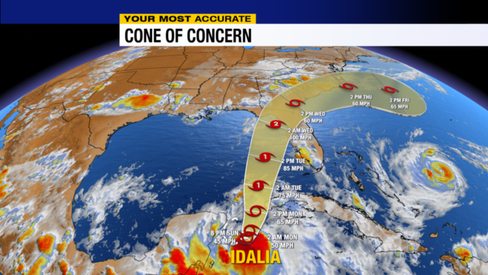
Tropical Storm Idalia is a little stronger, at 45 mph, at 8:00 PM Sunday, according to the latest advisory from the National Hurricane Center. Idalia will continue to strengthen over the next 72 hours, when it will have the chance to become a Category 2 hurricane in the eastern Gulf of Mexico.

Tropical Storm Idalia is moving to the east-northeast at just 3 miles per hour. Forward motion and strength will pick up over the next 24 hours, when Idalia will track into the Gulf of Mexico.

While the center of the hurricane will stay west of us in Southwest Florida, Idalia will have a lot of rain to the eastern side of it thanks to its strengthening and wind shear blowing the rain to the east of the center of circulation. Our in-house forecast model suggests that Idalia stays between 175-200 miles to the west of our coastline at its closest pass Tuesday afternoon, but the tropical storm force winds could scrape our coastline, especially areas west of U.S. 41.

This is why the National Weather Service has active Tropical Storm Watches and Storm Surge Watches for Lee, Charlotte, DeSoto and Collier Counties. These will remain active until the storm passes.


Here are the peak winds that we currently expect from Idalia. You can see that the tropical storm force winds (40 mph +) will be closer to the Gulf. This will not be a catastrophic wind event for Southwest Florida, but loose and light articles could get blown around in the 40 mph winds. So it’s a good idea to secure them now, before the storm passes by on Tuesday.

We can also expect to get some much-needed rain this week, with some locations getting 3″ to 4″ of rain, which would put a nice dent in the drought we have going on in Southwest Florida.
Stay with ABC7 and Your Most Accurate Forecast on TV and online with the “ABC7 WX” app, free wherever you get your apps. Install it and get the very latest from SWFL’s Most Accurate Forecast team, certified by WeatheRate 10 years running!


