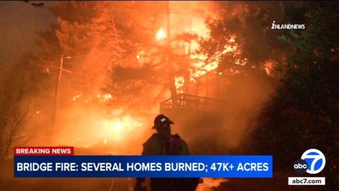
ANGELES NATIONAL FOREST, Calif. (KABC) — The Bridge Fire in the Angeles National Forest exploded to 47,904 acres Wednesday, after the flames destroyed several homes and threatened even more in communities like Wrightwood and Mount Baldy.
The wildfire started in the San Gabriel Canyon area Sunday afternoon near East Fork and Glendora Mountain roads. The blaze continued grow in size amid scorching temperatures, but it remained at 0% containment.
The Bridge Fire has exploded in size to 47,904 acres after the flames destroyed several homes and threatened communities like Wrightwood.
By Wednesday morning, it had spread north and northeast toward Wrightwood and Pinion Hills, prompting new evacuation orders and forcing residents to flee their homes.
One evacuee told Eyewitness News he has never seen anything like it.
“I’ve never seen this before, ever. There’s a possibility we might lose everything there,” said John Haskell of Wrightwood. “But our family is safe. Hopefully everyone gets out and no one gets hurt…. I’ve been through a lot of them. Nothing like this.”
Officials issued an emergency declaration after the Bridge Fire exploded in size Tuesday, crossing from Los Angeles County into San Bernardino County.
Firefighters confirmed at least a few homes burned, but no official count has been released.
Looking ahead, there’s a possibility winds could shift back to the west, which could create issues at higher elevations.
Evacuation orders for Bridge Fire
The Los Angeles County Sheriff’s Department issued a mandatory evacuation order for the East Fork communities of Camp Williams and River Community. An evacuation order was also issued for all residents north of San Antonio Dam up to the Mount Baldy Resort. Below is the full list of evacuation orders.
- Pinon Hills from Wrightwood north to Highway 18 and Beekley Road west to L.A. County
- Lone Pine Canyon from the community of Wrightwood to Hwy. 138/Lone Pine Canyon Road south to the forest
- Entire community of Wrightwood
- East Fork communities of Camp Williams Resort (café, mobile home park, campground) and River Community (near the resort)
- Mt. Baldy Road, all residents north of the San Antonio Dam up to the Mt. Baldy Resort
Evacuation warnings for Bridge Fire
- San Antonio Heights and Upland from the foothills south to the I-210
- Pinon Hills from Wrightwood north to Hwy. 138 and Lebec Road west to L.A. County
An evacuation warning was issued Tuesday night for northern Claremont as a precaution as the southeast portion of the Bridge Fire continues to burn, the city of Claremont announced.
“We urge everyone who’s under an evacuation order to leave now,” said Los Angeles County Fire Chief Anthony Marrone.
Where are evacuation centers located for the Bridge Fire?
An evacuation center was established at the Jesse Turner Center in Fontana and the Hacienda Heights Community Center. Below is the full list.
- San Bernardino County Fairgrounds: 14800 Seventh Street, Victorville, CA 92392
- Jessie Turner Health and Fitness Community Center: 15556 Summit Ave, Fontana, CA 92336. Call (909) 854-5100 (You can bring small animals in the company of owners)
- Pomona Fairplex: 601 W McKinley Avenue Pomona, CA 91768 (Enter Gate 3, corner of McKinley and White)
What about shelters for animals?
- Devore Animal Shelter (pets/livestock): 19777 Shelter Way, San Bernardino, CA 92407. Call (909) 386-9820, or after hours: (800) 472-5609.
- Palmdale Animal Care Center (small animals): 38550 Sierra Hwy, Palmdale, CA 93550
- Lancaster Animal Care Center (small animals): 5210 W. Avenue I, Lancaster, CA 93536
- Antelope Valley Fairgrounds (large animals): 2551 W. Avenue H, Lancaster, CA 93536. Call 562-706-8581 prior to arrival.
What roads are closed?
East Fork Road at Highway 39 was closed along with Glendora Mountain and Glendora Ridge roads. The California Highway Patrol also closed Highway 39 at the mouth of the canyon due to vehicle congestion. Mount Baldy Road was also closed at Shinn Road.
Forest visitors were being evacuated from the area, the Angeles National Forest announced on social media.
“The safety of our community members is our number one priority, and we will continue to assist residents in any way that we can. We encourage all residents in the affected areas who have been given an order to evacuate to please listen to the orders. If we’re asking you to evacuate, there is no property worth risking your life for,” L.A. County Sheriff Robert Luna said.
Below is a list of closures:
- State Route 138 from Lone Pine to Beekley Road
- State Route 2 closed from Big Pine to SR-138
- San Gabriel Canyon and East Fork of the San Gabriel River
- Mt. Baldy Road at Shinn Road intersection
Air quality in the San Gabriel Valley and the Inland Empire, due to the Bridge Fire and the nearby Line Fire, was labeled as “unhealthy.” Residents were urged to stay indoors or wear a mask when outdoors.
High winds and low humidity are aiding the spread of the fire, Cal Fire said. Firefighters are also hoping the upcoming cooler weather will slow the fire enough for them to gain the upper hand.
No injuries were reported. The cause of the fire was not immediately known.
City News Service, Inc. contributed to this report.
Copyright © 2024 KABC Television, LLC. All rights reserved.


