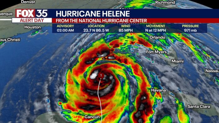
ORLANDO, Fla. – EDITOR’S NOTE: FOX 35 News will no longer update this article. Click here for the very latest on Hurricane Helene.
Hurricane Helene strengthened into a Category 1 storm on Wednesday and is expected to strengthen further – potentially becoming a major Category 4 hurricane – before making landfall over Florida on Thursday. Helene is likely to bring life-threatening storm surge, damaging winds, torrential rain, and flooding to parts of the Sunshine State.
Helene is the eighth named storm of the 2024 Atlantic hurricane season. If landfall happens over Florida’s Big Bend region, it would mark the third hurricane in the last two years to make landfall there (Hurricane Idalia in 2023, and Hurricane Debby in 2024).
WHERE IS HELENE | WHEN WILL HELENE REACH FLORIDA | IMPACTS | WATCHES & WARNINGS
Here’s the latest on Hurricane Helene’s anticipated path, cone, timeline, landfall, and impacts towards Florida.
Hurricane Helene was 350 miles southwest of Tampa, and 385 miles south of Apalachicola, according to NHC’s 2 a.m. Thursday update. The storm was moving north-northeast at 12 mph with maximum sustained winds of 90 mph. The storm remained a Category 1 hurricane but was expected to strengthen. A Category 2 hurricane’s wind speed ranges from 96-110 mph.
The minimum central pressure is 966 mb.

Timeline: When is Hurricane Helene expected to reach Florida?
Hurricane Helene is expected to strengthen further in the Gulf of Mexico, becoming a major hurricane (Cat. 4) before making landfall over Florida’s Big Bend region on Thursday night.
The latest track (cone) from the NHC is below. After making landfall, Helene was expected to weaken. However, due to the storm’s size, speed, and strength, strong, damaging winds are possible for much of the inland southeastern United States.
“On the forecast track, Helene will move across the eastern Gulf of Mexico today and cross the Florida Big Bend coast this evening or early Friday morning,” the NHC said. “After landfall, Helene is expected to turn northwestward and slow down over the Tennessee Valley on Friday and Saturday.”
Central Florida – Orlando and the surrounding cities – began to feel the impacts of Hurricane Helene on Wednesday. The weather will rapidly deteriorate on Thursday afternoon, including tropical storm-force winds, wind gusts, heavy rain, and the potential for tornado warnings.


The worst weather will be felt on Thursday evening, where much of Central Florida will experience tropical storm-forced winds, strong wind gusts, and heavy rain, up to 4″ possible in some spots. There will also be the chance for a tornado or two to develop. A more detailed, county-by-county breakdown of what to expect can be found here.


Stay connected with FOX 35


