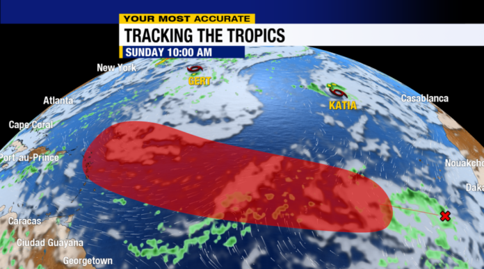
The historic peak of activity in the Atlantic during hurricane season is only days away, and so perhaps unsurprisingly, there is still plenty to track in the tropics. Here’s the latest:

Tropical Storm Gert
Tiny tropical storm Gert is being pulled into the wide circulation around the large non-tropical low-pressure area that was once Idalia in the north Atlantic. It will dissipate before the day is out — and this time, it will NOT reform.

Tropical Depression Katia
Katia continues to struggle to hold together in the far eastern Atlantic and was downgraded to a tropical depression overnight. The storm will be unable to overcome dry air and wind shear in its path, and as such, it is forecast to dissipate by tonight as well.
Invest 95L
A cluster of thunderstorms located about halfway between the Caribbean and Africa is showing signs of organization — and will likely be named a tropical depression or tropical storm in the next day or so, taking the name Lee. This will be a long-lasting storm that will very likely become a hurricane as it nears the Caribbean by the weekend.

There is strong agreement in the models this morning that the storm will turn to the north prior to reaching the Caribbean and the Bahamas. While there remains some uncertainty in the longer-range track, this does not look to be a threat to Florida. Regardless, we’ll be tracking it closely!

Other areas to watch:
Another disturbance will move off the coast of Africa later this week. It has a medium chance to develop. It will gain latitude quickly once it moves over the waters and looks to be headed to the central Atlantic. It is no threat to the U.S., regardless of development.

Stick with ABC7 as we continue to track the tropics for you through the remainder of the 2023 Hurricane Season.


